|
Location
|
Type
|
Description
|
| Spigot
Mortar Emplacement, Secretaries Farm, Bures |
GUN
EMPLACEMENT |
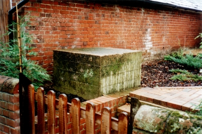
 Records
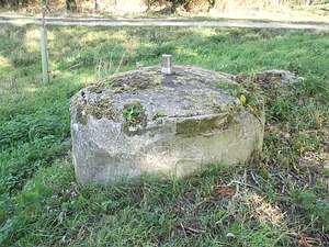
state, 2 spigot mortar positions, Secretaries Farm, S.E. corner
of grass field N. of and adj. stackyard. This second emplacement
still survives. It stands as an 18” high pedestal, surmounted
by its stainless steel spindle, at the SE corner of a large arable
field a few yards W of the public footpath. Around the pedestal
is raised earth; it is not known if ammunition alcoves survive
below ground level. Records
state, 2 spigot mortar positions, Secretaries Farm, S.E. corner
of grass field N. of and adj. stackyard. This second emplacement
still survives. It stands as an 18” high pedestal, surmounted
by its stainless steel spindle, at the SE corner of a large arable
field a few yards W of the public footpath. Around the pedestal
is raised earth; it is not known if ammunition alcoves survive
below ground level.
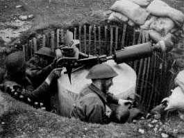
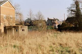
Example of Gun Emplacement, some were below ground as shown, others
were at ground level protected by concrete walls.
|
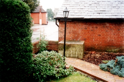
Spigot Mortar Emplacement.
Front entrance, Secretaries Farm, Bures
|
GUN EMPLACEMENT
(destroyed) |
Records state, "2
spigot mortar positions, Secretaries Farm, a) Adj. wall next to
front entrance. The front entrance of Secretaries Farm was on the
corner of Station Hill and Water Lane. It has now been moved down
Water Lane. Nothing more is known of this emplacement. |
| Station Hill |
Road Barrier/
Tank Trap
(destroyed)
|
Road Barrier. Station Road,
Bures. 8 concrete cubes & sockets for angle irons. Secretaries,
Bures. Front entrance. This road barrier crossed Station Hill,
not Road, between No. 3 (now known as Coppers) on the S side and
Secretaries Farm on the N side. On the S side one concrete block
still remains, 3’6 square, standing close to the front wall
in the garden of No. 3. The front entrance of Secretaries Farm
was on the corner of Station Hill and Water Lane. It has now been
moved down Water Lane. As the road barrier on Bures Bridge guarded
against attack from the E and the one across Colchester Road defended
the town against an advance from the S, so the road barrier across
Station Hill blocked the approach from the W.
Part of tank trap still to be seen
in a front garden along Station Hill
|
| Bures Bridge |
Tank Trap
(destroyed) |
Road Barrier. At
Bures Bridge. (River Stour). No trace of this barrier now remains. |
| East
of the current Millenium Bridge |
River Obstruction.
This can only be seen during the
summer months when vegetation grows around that immediate area
in the centre of the river
|
|
| Road
Barrier , Cambridge Brook/Colchester Road, Bures |
Tank
Trap
(destroyed) |
Road Barrier. Adj. Cambridge
Brook, Bures. This is where the anti-tank ditch of the Eastern
Command Line at this point Cambridge Brook crossed Colchester
Road.
|
| Bures
Bridge |
Pill
Box
|
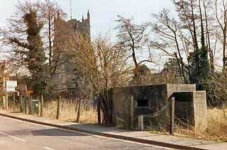
30 yards from Bures Bridge,
at the side of a field close alongside the pavement, is an FW3/22
concrete pillbox.
It has 15 thick walls, 10 loopholes with steel side
pieces, and an entrance on the SW face.
|
| W of River, S of
Village |
Pill Box (destroyed) |
2 pillboxes &
deposit of silt from river dredging, between R. Stour & Colchester
Road. An aerial photograph taken in 1946 shows the indistinct shape
of a pillbox, at the N end of field, by the W bank of the R. Stour.
Nothing now remains. |
| NW of Cambridge Brook/Colchester
Road road Barrier, Bures |
Pill Box (destroyed) |
Pillbox. Between
railway line & Colchester Road. An aerial photograph taken in
1946 shows the indistinct shape of what is probably a pillbox standing
on the SW side of Colchester Road at this point some 60 yards NW
of the Cambridge Brook/Colchester Road road barrier Its type cannot
be determined. Nothing now remains. |
| E of Crossing Mount
Bures |
Pill Box (destroyed) |
A/T ditch, clearing
of bank & pillbox, N.W. of Rectory & adj. railway. Aerial
photographs taken in 1946 and 1949 show this pillbox or its remains
standing immediately to the E of the road junction about 40 yards
E of the level crossing. The pillbox type cannot be determined.
|
| Anti-Tank "Pimples"
, Colchester Road, Bures |
Tank Trap
(destroyed) |
 Records
state, 6 concrete pimples. Builders Yard & premises, Colchester
Road. The builders yard was on the W side of Colchester Road immediately
S of the road barrier. The area is now no. 12 Colchester Road.
The pimples were probably an extension of the road barrier. Records
state, 6 concrete pimples. Builders Yard & premises, Colchester
Road. The builders yard was on the W side of Colchester Road immediately
S of the road barrier. The area is now no. 12 Colchester Road.
The pimples were probably an extension of the road barrier.
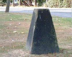
Example of tank trap - many
of these concrete cones would have formed an impenetrable grid
type network across a road or access.
|
| Spigot Mortar Emplacement,
former coal dump, Bures |
GUN EMPLACEMENT
(destroyed) |
Records state, Spigot
mortar position & restriction of user of land to prevent blocking
field of fire. Yard to N. of Old Gas Works & now used as Coal
Dump, Colchester Road. The gas works stood where the petrol station
now is on the E side of Colchester Road and it stretched around
the back of the houses nos. 1, 3 & 5. Nothing more is known
of this emplacement although from its siting it is probable that
it was positioned to fire on Bures Bridge. |
| Road Barrier, Colchester
Road, Bures |
TANK TRAP
(destroyed) |
Records state, 4
sockets for angle irons. Cottage in Colchester Road, front garden,
3 sockets for angle irons. Rushmore, Colchester Road, Front garden
and 1 socket for angle iron. Cottage in Colchester Road, Front garden.
These entries refer to a socket and rail road barrier across Colchester
Road between nos. 29 (4 sockets) and 27 (1 socket) on the E side
and Rushmere (3 sockets), not Rushmore, on the W side. |
| Spigot Mortar Emplacement
Colchester Road, Bures |
GUN EMPLACEMENT
(destroyed) |
Records state, Spigot
mortar position & hinging of portion of fence. Builders Yard,
Colchester Road, S.E. corner. The builders yard was on the W side
of Colchester Road, immediately S of the Road Barrier This area
is now No. 12 Colchester Road. |